Nearmap documenting the recovery post-bushfires and floods across Australia

In September last year, Australian aerial imagery company Nearmap embarked on a project to capture footage of areas around the country that were prone to bushfires.
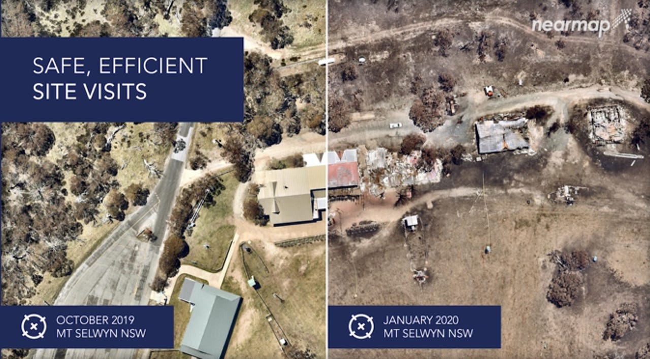
At the start, Nearmap had captured the Queensland Sunshine Coast and Scenic Rim region. The project was on track, with captures across the state, as well as in New South Wales, Victoria, and South Australia, when the black summer bushfires of 2019-2020 hit.
Australia was devastated by the fires that burned over 17 million hectares of land, claiming over 3,000 properties. The lives of 33 people were also taken.
Presenting the project as part of Nearmap's virtual Navig8 customer event on Thursday, Nearmap's ANZ director of survey operations M'Shenda Turner discussed the project that saw the company shift its focus to post-bushfire capture.
The program spanned six months and added over 15,000 square kilometres to Nearmap's standard coverage footprint.
Acknowledging the continued suffering of those affected by the bushfires, Turner said the focus of the project was on areas with the most property or infrastructure loss.
She said such surveys are difficult to plan, difficult to organise, and can be very difficult to capture.
"The pace and the breadth of the season required continued planning and re-planning, immediate information was sometimes fairly scarce and I used the relevant state brigade websites and media reports to guide my planning and our flight maps," she explained.
Nearmap partnered with not-for-profit disaster response agencies such as Disaster Relief Australia (DRA). Turner said Nearmap imagery assisted DRA's mapping and recon teams who collate location intelligence before deploying volunteers on the ground.
DRA also provided local government teams and the Australian Defence Force with information on what properties were damaged to help prioritise the checking of people's welfare and relief for residents, she said.
Further use cases, Turner explained, are for local council or law enforcement who can use Nearmap footage to see which roads would need to stay closed, which is one such example.
"Beyond the initial incident, you can determine if there are any threatening trees that need to come down before the road can open again or if there are electricity poles or other essential infrastructure that has been impacted," she said.
"With that information, safety tours can easily and quickly be planned so local traffic at least can start moving around again."
Environmental agencies can also check, for example, if there are wetlands or catchment areas that are in threat due to toxic run off or debris so containment plans can be organised. Ploughing through the data can also aid clean up efforts, too.
Insurers can also use the imagery when dealing with claims.
"It's not just government agencies and private business that derive great value out of these captures from the initial phases all the way through to complete recovery," she said, showing captures of Mallacoota in Victoria.
"After years of drought, the colour brown was my constant companion and then there was about five months of nothing but black and burnt imagery," she recalled. "Then, weeks of sweeping rainstorms in February."
After this, she said it was the first time she saw green paddocks in a very long time.
"We started to see the first patches of regrowth in some of the bushland," Turner said. "Don't get me wrong, this area still suffered a lot of damage, but with some rain and a little bit of time, the burnt paddocks had really come back with a vengeance. There were positive signs of life and recovery."
Updated at 10:15am AEST, 11 August 2020: Corrected error by changing Disaster Recovery Australia to Disaster Relief Australia.
RELATED COVERAGE
- Data science vs social media disinformation: the case of climate change and the Australian bushfires
- Twitter bots and trolls promote conspiracy theories about Australian bushfires
- Bushfire Recovery Victoria tapping into data to help bushfire-affected communities
- The Internet of Wild Things: Technology and the battle against biodiversity loss and climate change (TechRepublic)